New Home Plans in Carmel Valley, CA
Custom house plans for valley floor, hillside and ranch parcels, drawn around the Carmel Valley Master Plan, the oaks, the water source, the septic field and the fire road before the first floor plan.
Quick version: Carmel Valley is unincorporated Monterey County, and nearly everything about a new house here is shaped by the Carmel Valley Master Plan before the building code comes into play: design review on almost every lot, a permit for each oak you want gone, a 100-foot setback along Carmel Valley Road and limits on steep, erodible ground. Water and wastewater are the other two deciders. We start with those, then draw the Design Approval package and the County building set and upload them through the County’s Digital Plan Room. Call 805-712-8993.
Start with the lot, not the floor plan
The County of Monterey decides every new home in the valley, from the mouth near Highway 1 out past Carmel Valley Village. Its Carmel Valley Master Plan supplement policies, Chapter 9.B of the 2010 General Plan, add local rules on top of the zoning, and several of them decide where a house can sit at all. The Cachagua area farther east has its own area plan (Chapter 9.A), so we confirm which plan covers the parcel first. Before any layout, we pull the zoning and overlay districts from the County’s parcel records and map the site against these questions:
- Is the lot a legal lot of record? The Master Plan caps new subdivision in the valley, but its count covers new lots, accessory units and houses beyond the first. The first single-family home on an existing legal lot is not part of that cap, and the plan’s traffic policy for discretionary projects does not apply to it either.
- Does it front Carmel Valley Road? Policy CV-3.1 sets a 100-foot minimum setback from the road for all abutting properties, with exceptions only for structures permitted before the original Master Plan (December 16, 1986) or where the setback would leave a lot unbuildable. The plan also discourages extra driveway connections to the road.
- Is it open grassland seen from the road? Buildings proposed in open grassland that would be highly visible from Carmel Valley Road or Laureles Grade are to be kept few in number and clustered near existing natural or built vertical features, such as a tree line (CV-1.9). Views of the river and the distant hills from Garland Ranch Regional Park, Carmel Valley Road and Laureles Grade are protected for existing lots too (CV-3.3).
- How steep is it, and what is the soil? Non-agricultural development on slopes over 25 percent that are also highly erodible is prohibited, and other ground over 25 percent falls under the General Plan’s slope policy (CV-3.22). New roads should not cross slopes over 30 percent unless erosion and scarring can be mitigated (CV-2.9).
- Is it on the Carmel River? Development has to be sited to protect riparian vegetation, limit erosion and keep the river’s visual character, and where it is gone the plan calls for replanting up to 150 feet from the river bank or the face of an adjacent bluff, whichever is less, with density transferable to the rest of the lot (CV-3.8). The site plan also shows creeks, wetlands and the 100-year floodplain where they apply.
- Is it in a special area? The Santa Lucia Preserve, Carmel Valley Ranch and a few named properties carry their own Master Plan provisions. Preserve lots follow the Preserve’s development plan and its own review board as well; see our Santa Lucia Preserve house plans page.
Design review under the Master Plan
Policy CV-1.20 applies Design (“D”) and Site Control (“S”) overlays to the Carmel Valley area and requires design review for all new development in the valley, including proposals on existing lots of record, leaving out only minor additions that are not conspicuous from outside the property. The plan asks for a rural design theme and lists what the review weighs. We treat that list as the design brief:
- a house that is visually compatible with the valley and its immediate surroundings;
- materials and colors chosen to suit the structure and its natural and built setting;
- height and bulk kept to an appropriate scale;
- a building site, and road cuts, placed to limit disruption of views from existing homes;
- as little landform change and erosion as possible, with grading reduced through stepped and pole foundations on slopes.
The County’s Design Approval guidelines matrix for D, S and VS districts notes that projects in “S” and “VS” districts get a staff site visit and can need other discretionary permits, that viewshed policies are checked for every project, and that a new second story can go to a public hearing when it could have a substantial adverse impact. Its notes also flag every new house on septic for referral to the Environmental Health Bureau. On the hillsides above the valley floor, we draw the massing low and test it against the views from the road before elevations are fixed.
The Design Approval package
The County’s Design Approval request instructions spell out what HCD Planning needs, starting with the request form and, for inland parcels like Carmel Valley, the General Plan Consistency Checklist. The drawings we prepare for it:
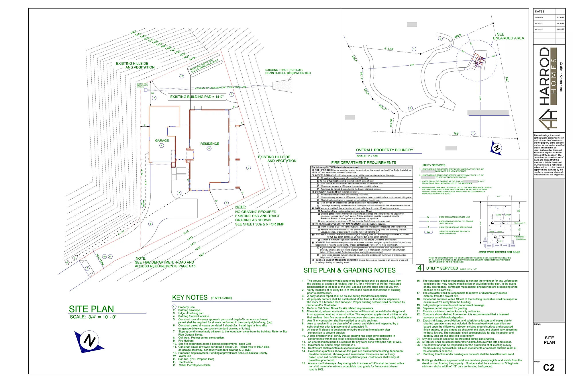
- A detailed site plan: parcel number, preparer, north arrow and scale; boundaries with dimensions; roads, rights-of-way, driveways, easements and parking; every existing and proposed structure, fences included; two-foot contours; drainage; wells, septic tanks and leach fields; sewer and water lines; trees by type and size, marked to remain or be removed; wetlands and creeks; setbacks; flood areas; grading with cut and fill and the tallest cut or fill slope; and lot size, coverage, floor area ratio and impervious coverage, in square feet and percent.
- Grading plans stating what the grading is for, with quantities, retaining walls, cross sections, finished contours and any existing erosion.
- Floor plans showing room sizes, entrances, exits and stairs, and which walls stay or go on a rebuild.
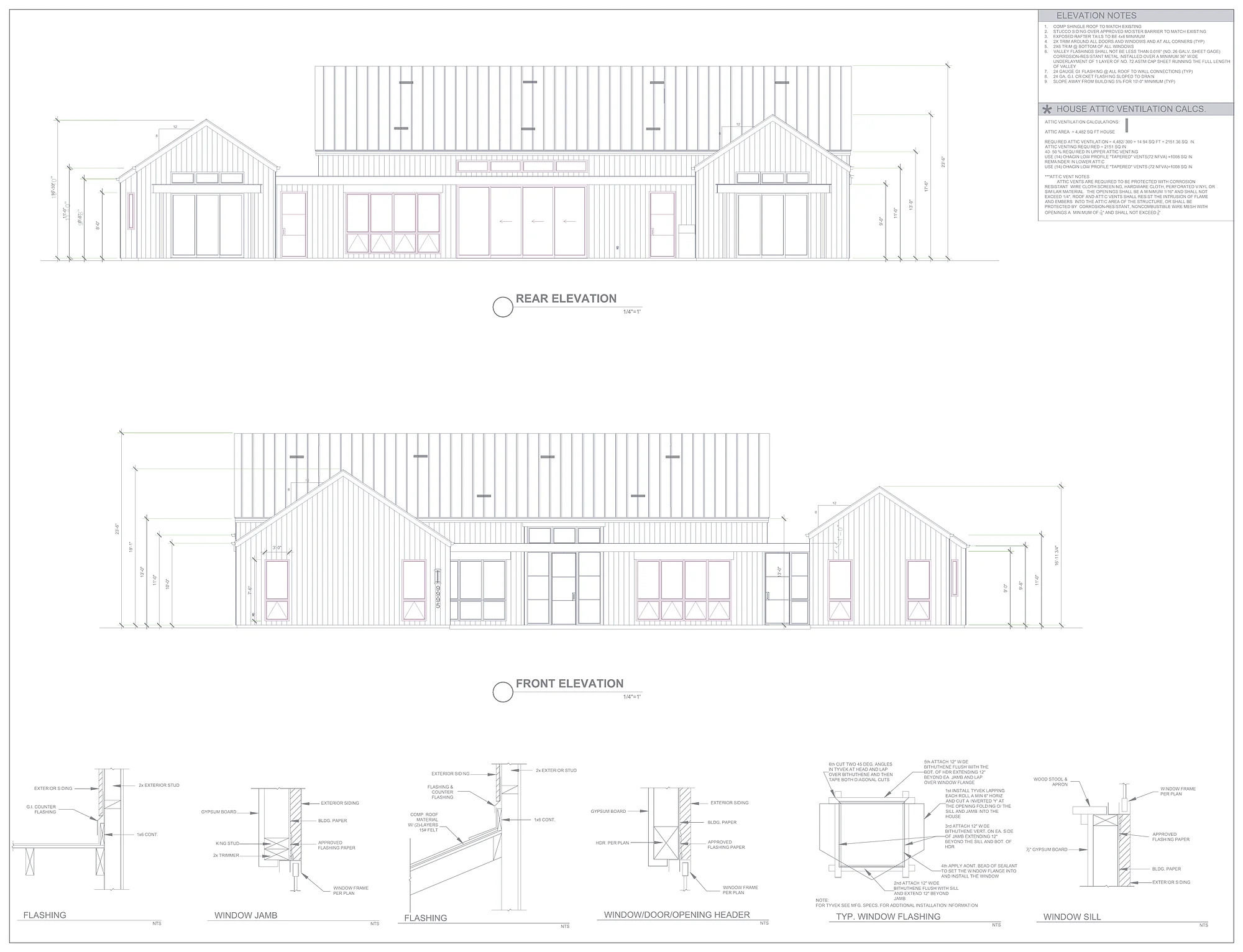
- Elevations of all four sides with wall and roof materials, roof equipment, finished floor elevations and the height dimensioned from average natural grade.
- Site photos and two samples of every exterior paint, stain and roof color.
Staff may refer the application to the local Land Use Advisory Committee for a recommendation before the decision, and the County recommends that the applicant attend that meeting. We prepare the presentation drawings and can walk the committee through the design.
Oaks, madrones and redwoods
Policy CV-3.11 discourages removing healthy native oaks, madrones and redwoods anywhere in the Master Plan area and requires a permit to remove any of them with a trunk diameter over six inches, measured two feet above ground, with nursery-grown replacements of the same species where feasible. The County’s tree removal procedures add the working rules:
- There is no over-the-counter review unless a tree is hazardous.
- An administrative permit for three trees or fewer needs the application, a tree assessment report from a County-certified tree consultant, a site plan and photos. Removals within the prior year count toward the total, and a fourth tree in that window takes a use permit.
- Between February 22 and August 1, the consultant has to look for bird nests within 300 feet, and a found nest means a survey by a County-qualified biologist before approval.
- Signs of sudden oak death send the request to the Agricultural Commissioner first.
The Design Approval site plan has to show every tree to remain or be removed by type and size, and the Master Plan’s landscape policy favors native plants, with valley oaks on floodplain terraces. We bring the arborist’s tree survey into the site plan early so the driveway, the leach field and the house can be fitted between the canopies before anyone files for a removal.
Water: find the source first
Water often decides whether, and how big, a Carmel Valley house can be. A lot can be on the California American Water (Cal Am) system, a small water system or a private well, and each path asks for different paperwork. New Cal Am connections on the Peninsula are still under the State Water Board’s cease and desist order moratorium. According to the water management district’s CDO update, its board voted in October 2025 to request that the moratorium on new meters be lifted; the State Water Board announced on June 19, 2026 that it would hold a hearing on the written record, and it scheduled an oral public comment day for November 5, 2026, with closing briefs on November 10. Until the Board rules, we look for an existing connection or water credits on the lot. On a teardown, the district’s water credits page explains that removing fixtures, including by demolition, documents credits that are good for ten years.
Inside the district’s boundary, a water permit is required for any new connection or added fixtures, and the district’s process only begins once the County has finished checking the plans. A County staff member signs the Water Release Form; the stamped, approved set then goes to the district by email or to its Ryan Ranch office, because it will not take concept drawings; district staff inspect the existing fixtures when there is no inventory on file; and the owner signs notarized deed restrictions that the district records. With the water permit in hand, the owner returns to the County for the building permit, and at the end of construction the district inspects separately from the County. The residential application form counts fixtures by value, so the plumbing plan matters: a high-efficiency toilet counts 1.3 and an ultra-high-efficiency toilet 0.8, a standard tub or shower 2.0, each extra showerhead another 2.0, a kitchen sink 2.0 (1.5 with a high-efficiency dishwasher), only one master bath per home at 3.0, a pool 1.0 for each 100 square feet, and an instant-access hot water system earns a 0.5 credit.
For a well, Master Plan policy CV-3.20 requires a discretionary permit for any new well in the Carmel Valley alluvial aquifer, with any increase in extraction fully offset. The County’s well program then needs an application signed by the owner and filed by a C-57 licensed driller, keeps wells 100 feet from septic tanks and leach fields and 50 feet from sewer lines, and requires at least 2.5 acres where the lot uses septic but could be served by a water system. A new domestic well needs water quality results, and source capacity testing may be required.
Septic and the Environmental Health Bureau
Many parts of the valley are not served by a regional sewer. Master Plan policy CV-5.5 asks projects with an onsite system for geologic and soils surveys showing the system will not threaten the aquifer, and calls for careful review of new homes on existing lots for siting and design under County Code Chapter 15.20, the Central Coast Basin Plan and the Carmel Valley Wastewater Study. The Environmental Health Bureau’s septic permit page, under its Local Agency Management Program, lists what it needs to evaluate a new system:
- a wastewater generation estimate from Table C of Chapter 15.20;
- an OWTS feasibility report by a qualified professional, with at least one deep groundwater monitoring boring and a site evaluation, soil profile and percolation tests for both the primary dispersal field and the expansion area;
- a system design by a qualified designer showing room for the primary and secondary dispersal systems and, where required, a 100 percent future expansion area;
- the owner-signed OWTS application, filed with the construction permit application, followed by a site visit once the feasibility report is accepted.
Lots that cannot take a conventional system may need an alternative system with supplemental treatment, which also needs an ongoing permit from the Bureau for its upkeep and monitoring. Because the field, its reserve and the well setbacks can fill a large part of a small parcel, the septic study comes before the house plan, not after it.
Fire district conditions
Most of Carmel Valley is protected by the Monterey County Regional Fire District, whose stations include Laureles, the Village, Mid Valley and the Santa Lucia Preserve. The rural, mountainous east end around Cachagua is served by the Cachagua Fire Protection District. The Regional District’s forms and checklists include the County fire prevention officers’ general fire conditions matrix, whose items go on the plans as “Fire Dept. Notes”. The ones that most often move a site plan:
- Access within 150 feet of every part of the first-story walls, on an all-weather surface built for 22-ton apparatus.
- Driveways of 12 feet minimum width and 15 feet of overhead clearance, with grades capped at 15 percent and an asphalt structural section required past 8 percent, a turnout near the midpoint of drives between 150 and 800 feet, and a turnaround within 50 feet of the house on any drive longer than 150 feet.
- Gates set at least 30 feet back from the road and at least 12 feet wide.
- Fire water supply where there is no hydrant system: 4,900 gallons for structures under 3,000 square feet, 9,800 gallons at 3,000 square feet or more, and possibly more above 10,000, all in addition to domestic demand. A hydrant or fire valve, where required, sits between 50 and 1,000 feet by road from the house.
- Setbacks of 30 feet from property lines and the road center on parcels of an acre or more, and 30 feet of defensible space around structures as the standard.
- Automatic fire sprinklers in the entire house and any attached garage, designed and submitted by a C-16 fire protection contractor, and a household fire warning system to NFPA 72 from a C-10 contractor.
- Address signs at each driveway entrance, posted when construction starts.
The matrix is older and still cites the earlier model codes, so we confirm the current conditions with the fire district for each parcel. The District’s 2025 hazard zone page notes that it received the State Fire Marshal’s updated local maps on March 10, 2025, that homes in Very High zones need 100 feet of defensible space, and that new construction in mapped zones follows the wildland-urban interface building rules. Where a parcel is in State Responsibility Area, its zone comes from the State Fire Marshal’s hazard zone maps (effective April 1, 2024). We look up the zone for the parcel and draw the vents, roofing, siding, decks and windows to match.
The County building set and the Digital Plan Room
Once the design is approved, the County’s building permit submittal requirements for a new single-family home list seven pieces: the full site plan; the complete construction drawings, which the County sends on to every agency with a say; engineered structural calculations; the Title 24, Part 6 energy forms; truss drawings and calcs, allowed as a deferred submittal as long as they arrive before truss erection; one or more geotechnical reports; and a review letter from the soils engineer. The preparer signs and dates each sheet in ink before the permit issues, and the first sheet shows the job address. The County’s site plan guide adds slopes of 30 percent and more, finished floor elevations, floor area per floor and every tree by species and diameter.
Applications go through the County’s Accela Citizen Access portal, which also handles tree permits, encroachment permits and new address assignment, and as of September 1, 2026 plan review runs in the ePermitHub Digital Plan Room. We build the files to its rules:
- every file a PDF of 500 MB or less, never password-protected or encrypted, knowing that any markups in it are stripped on upload;
- drawings and reports in separate files, with calculations and reports merged into a single PDF that is replaced in full whenever anything changes;
- drawings set up landscape and to the stated scale, numbered at the lower right with consistent numbers from submittal to submittal, and exported with a bookmarked sheet list;
- a clear area at the upper left of every building sheet, where the County places its approval stamp.
How a Carmel Valley new home moves with us
- Parcel research: zoning and overlays, legal lot status, frontage on Carmel Valley Road, slopes and soils, the river and creeks, protected trees, the fire district and hazard zone, the water source and septic feasibility.
- Consultants lined up: survey and topography, the tree consultant, the septic feasibility study and, for a well, the driller and hydrology work, plus the geotechnical engineer.
- Site plan and massing: the house, driveway, fire turnaround, leach field and water storage placed together, then floor plans, elevations, colors and photos for Design Approval, with the advisory committee meeting.
- County building set: construction drawings, structural and energy work, grading and drainage, uploaded to the Digital Plan Room with the Environmental Health and fire submittals.
- Water permit: the fixture count and landscape plans for the water management district after plan check, where the lot is inside its boundary.
- Construction: our sister company Harrod Built can give you costing as the design comes together and build it when your plans are approved.
Our work and the plan set
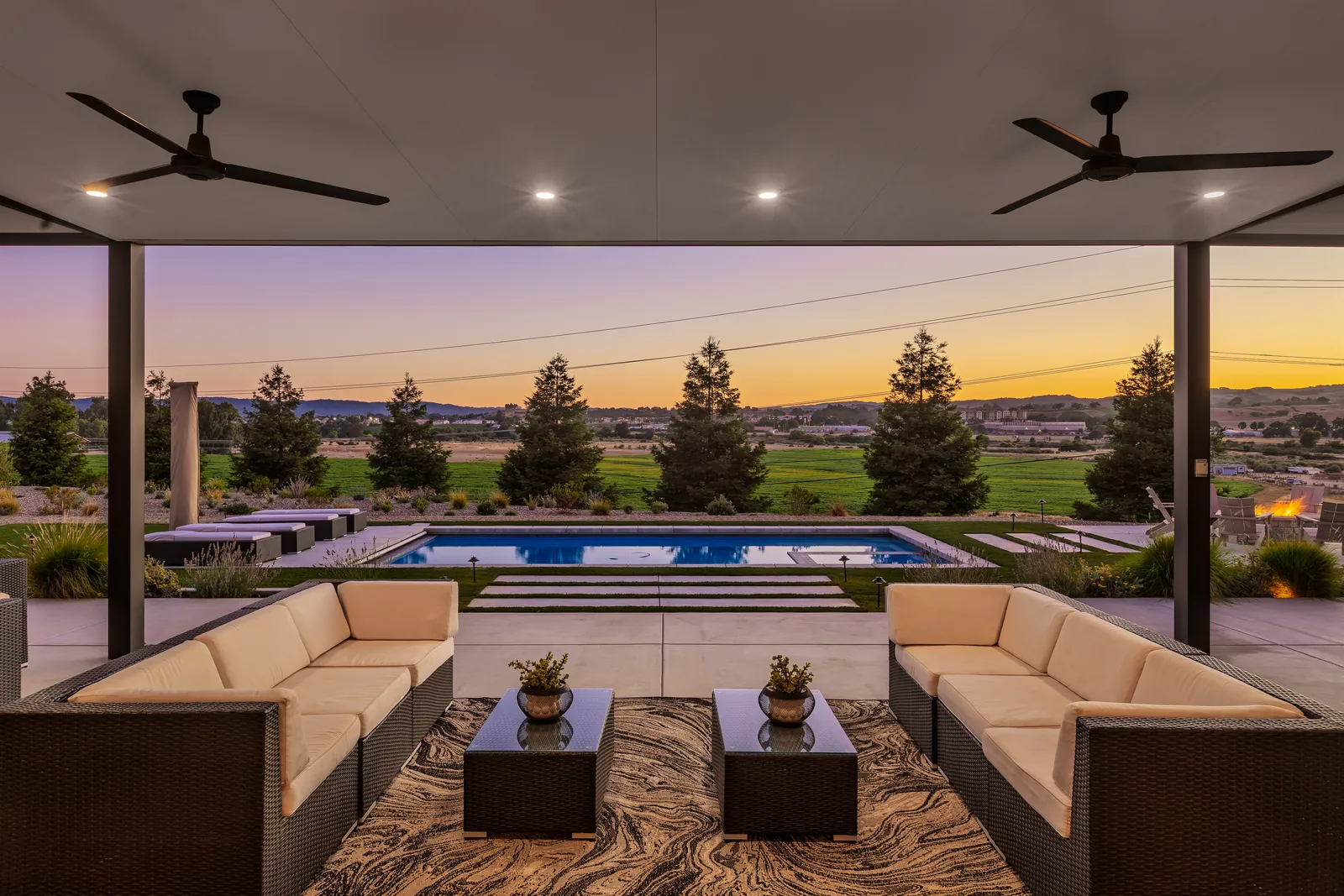
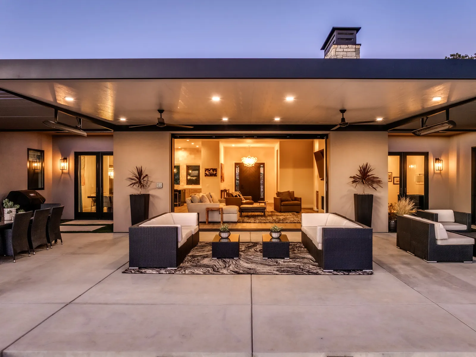
Harrod Drafting & Design works from Paso Robles. The plan sets we publish are North San Luis Obispo County homes, and none of them are Carmel Valley projects. To see how complete our drawings are, look at the Templeton Modern French Country set, shown next to photos of the built house, or read our sheet-by-sheet permit set guide. California Business and Professions Code section 5537 lets a building designer draw wood-frame dwellings no taller than two stories over a basement; a licensed civil or structural engineer handles and stamps the framing design, and a geotechnical engineer signs the soils work. On a valley lot we also bring in the land surveyor, the certified tree consultant and the septic designer.
Homes and plans from our studio
Finished homes, 3D design views and plan sheets from Harrod Drafting & Design projects across the Central Coast. See more on our portfolio page.
Looking at acreage off Highway 68 instead? See Corral de Tierra home design and drafting.
Carmel Valley new home questions
Who approves a new house in Carmel Valley?
Carmel Valley is not a city, so the County of Monterey’s Housing and Community Development department handles both the planning side and the building permit, and plans are uploaded through its Accela Citizen Access portal and the ePermitHub Digital Plan Room. Along the way the set is also checked by the fire district, the Environmental Health Bureau when the lot uses septic or a well, and the Monterey Peninsula Water Management District when the house draws on a water system inside its boundary.
Does every new Carmel Valley home go through design review?
Almost always. The Carmel Valley Master Plan applies Design (D) and Site Control (S) overlay districts across the valley and calls for design review of all new development, including houses on existing lots of record. Only minor additions that cannot be seen from outside the property are left out. In practice that means a Design Approval application with elevations, colors, a detailed site plan and photos, which staff may send to the local Land Use Advisory Committee before a decision.
Can I take out oak trees to fit the house?
Only with a permit. The Master Plan requires one to remove any oak, madrone or redwood with a trunk over six inches across, measured two feet above the ground, and asks for replacement planting of the same species where feasible. The County’s tree procedures call for a report from a County-certified tree consultant, and removing four or more protected trees within a year moves the request to a use permit, so we try to site the house around the trees first.
Where will the water for a new house come from?
It depends on the lot. New Cal Am service connections on the Monterey Peninsula are still under a State Water Board moratorium, which the water management district has asked the Board to lift (a public hearing day is set for November 5, 2026). A lot may instead have an existing connection or water credits, a small water system or its own well. The Master Plan requires a discretionary permit for a new well in the Carmel Valley alluvial aquifer, and the County well program adds its own siting rules. We confirm the source before we design.
What does septic mean for the house design?
A lot on septic needs an OWTS feasibility report from a qualified professional, with at least one deep groundwater boring, soil profiles and percolation tests for the primary and expansion dispersal areas, and then a system design. The approved field and its reserve area take up real space, and wells have to stay 100 feet from tanks and leach fields, so the septic layout often decides where the house, driveway and garage can go.
What fire rules affect a Carmel Valley house plan?
Most of the valley is served by the Monterey County Regional Fire District, while the Cachagua area at the east end has its own fire protection district. The District’s standard conditions call for automatic fire sprinklers in the house and attached garage, a 12-foot driveway with grades of 15 percent or less, a turnaround once the driveway passes 150 feet, a stored fire water supply where there is no hydrant, and a 30-foot setback from property lines on parcels of an acre or more. Hazard zone maps then add defensible space and wildfire-resistant construction.
More for the area: our Carmel Valley design and drafting overview, house plans for the Santa Lucia Preserve, the Monterey County hub, the Pebble Beach new home guide, County ADU plan sets (and our Carmel Valley ADU guide), and nearby Carmel-by-the-Sea (and our Carmel-by-the-Sea new home guide) and Carmel Highlands. Farther south: Montecito new homes. Everywhere: custom home design, what a permit set includes and all the areas we serve.
Ready to build in Carmel Valley?
We design with real construction costs in mind, and our sister company Harrod Built can give you costing as the design comes together and build it when your Carmel Valley plans are approved. Same family, same office.
Nearby custom home guides: custom home design in Monterey, custom home design in Pacific Grove and custom home design in Big Sur.
Get a quote for new home plans in Carmel Valley
Phone 805-712-8993 or fill in the form. Helpful details: the parcel number or address, the water source (Cal Am, a mutual or small water system, or a well), any survey, tree report or septic study you already have, and the size and style of home you are picturing. Our contact page has other ways to reach us.
Sources for this page: the County of Monterey’s 2010 General Plan page and Carmel Valley Master Plan supplement policies (as amended in 2013), Design Approval request instructions and guidelines matrix, tree removal permit procedures, building permit submittal requirements, site plan guide, online permit information and Digital Plan Room pages; the County Environmental Health Bureau’s septic permit and well program pages; the Monterey County Regional Fire District’s forms and checklists, general fire conditions matrix and 2025 fire hazard severity zone page; the Cachagua Fire Protection District; the hazard zone maps of the Office of the State Fire Marshal; and these Monterey Peninsula Water Management District pages: when a water permit is required, the application process, the residential water release form, water credits and the application to modify the cease and desist order (checked October 18, 2026). Agencies update these rules often; before design starts on any parcel we check them again with the County, the fire district and the water district.